The Auglaize County Historical Society

Buckland | Cridersville | Ft. Amanda | Minster | New Bremen | New Knoxville
St. Johns | St. Marys | Uniopolis | Wapakoneta | Waynesfield | Bottom of Page

Auglaize County Map

  1. LOCAL HISTORY MARKERS: A series of six panels outlines the history of the Shawnee Indians who established their village at Wapakoneta in 1782. Located at 203 South Wood Street at the Temple To Humanity.
  2. BOYHOOD HOME OF NEIL ARMSTRONG: The home is now a private residence. Located at 601 West Benton Street.
  3. WAUPAUGHKONETA RESERVATION MARKER: It marks the eastern-most boundary of the reservation established for the Shawnee in the Treaty of the Maumee Rapids in 1817. Located at the corner of US 33 and SR 65, east of St. Johns.
  4. DEEP CUT PARK: A roadside park along the section of the Miami-Erie Canal where a "huge ditch" over 6,000 feet long, ranging from 5 to 52 feet deep, was dug in the 1840s as part of the canal. Markers outline the history of Deep Cut and the canal. Located 9 miles north of St. Marys on SR 66.
  5. SIX MILE AQUEDUCT: The aquaduct was built in the 1840s to carry the Miami-Erie Canal over Six Mile Creek. Later the flodd gates and headwalls were removed to let more water out of the canal - hence the waterfall. Located 5.5 miles north of St. Marys on SR 66.
  6. BLOODY BRIDGE: This marker outlines the tragic story of Minnie Warten and her two suitors that took place during the canal days of the 1850s. Located 5 miles north of St. Marys on SR 66.
  7. LOCK 14: This concrete lock, built in 1907, replaced the original wooden lock for the Miami-Erie Canal. The marker relates a brief history of the tiny hamlet that grew up around the lock. Located 4 miles north of St. Marys on SR 66, then west on Lock 14 Road.
  8. FORTY ACRE POND: Pond was constructed as a feeder for the Miami-Erie Canal. A marker near the bridge relates facts about the pond. This is a very scenic site. Located 2 miles north of St. Marys on SR 66, then west on Glynwood Road.
  9. MURRAY CEMETERY: The first civilian cemetery in the area. The Marker lists all known early burials and outlines some local history. Located in K.C. Geiger Park on Greeenville Road.
  10. GIRTY'S TOWN MARKER: The marker tells the history of Girty's Town, the early name for St. Marys, and the Simon Girty family. Located at the corner of Spring and Wayne Streets.
  11. FORT ST. MARYS MARKER: This is the site of the fort built by General Anthony Wayne's troops in 1794. Ft. Barbee, built during the War of 1812, occupied the same site near the banks of the St. Marys River. Located in the old Lutheran Cemetery two blocks east of Main Street, south of the Daniel Mooney Museum; watch for signs.
  12. OFF-SHORE OIL WELLS: In 1891, the world's first off-shore oil drilling took place here. The marker outlines the history of the many oil rigs that once stood in Grand Lake St. Marys. Located on the west side of SR 364 near the shelter house at Grand Lake State Park.
  13. MIAMI-ERIE CANAL PLATEAU MARKER: The marker explains the plateau that was the high point along the canal's 249 mile length. Located on Washington Street near the public library.
  14. PLANK ROAD MARKER: This marker outlines the history and rates of toll for the toll road built of oak timbers in 1850-52 between Wapakoneta and St. Marys. Located in Moulton near the intersection of County Road 33A and Moulton Road.

Back to Top

Buckland

WhitefeatherWhitefeather's Town Marker ~ This marker outlines the history of the large Shawnee Indian town that was once located nearby, along the banks of the auglaize River. The village of Buckland was originally called Whitefeather. The name was changed with the coming of the railroad in 1891. Located east off of North Main Street, a drive goes back to the cemetery, the marker is at the entrance to the park.

Back to Top

Cridersville

Bowsher Log HouseDaniel Bowsher Log House ~ This log home was built in 1836 by one of the earliest pioneer families in the Cridersville area. It is furnished to represent the pioneer lifestyle of the 1830s and 1840s. Located at 507 East Main Street. Hours May-October: First and third Sunday of each month, 1:00 pm - 5:00 pm.

Back to Top

Fort Amanda

Ft. AmandaFort Amanda was built during the War of 1812 under the orders of General William Henry Harrison. The cemetery at the site contains the graves of 75 unknown soldiers who were killed at the fort during the war. A fifty foot tall granite obelisk was erected as a monument to the fort in 1915. Monument and signs relate history of the site. Walking paths and picnic facilities are available. Located 7.5 miles north of Wapakoneta on SR 198 at the Auglaize/Allen County line. Open dawn to dusk may through October.


Back to Top

Minster

St. Augustine Church


St. Augustine Church ~ The outstanding landmark on the Minster horizon is without a doubt St. Augustine Catholic Church. The original portion of the building dates back to 1847. The massive twin spires were added in 1874. Located at 48 North Hanover Street.

Minster Historical Center ~ The Minster Historical Society has an exceptional genealogical and historical research center located on the second floor of the Stallo Memorial Library. It contains extensive genealogical files, historic photographs and documents relating to Minster's past. Located at 196 East 4th Street. Hours: Monday 3-8 pm, Tuesday 1-8 pm, Wednesday 4-8 pm, Friday 10 am - 6 pm, Saturday 9 am - 2:30 pm, closed Thursday and Sunday.

Back to Top

New Bremen


New Bremen has several beautifully restored 19th century brick homes and commercial buildings in its downtown.

New Bremen Historic Museum ~ The museum is located in a clapboard home built in 1837, one of the oldest buildings in New Bremen. It contains a wonderful collection of furniture, artifacts and historic photographs from the New Bremen area. Located at 120-122 North Main Street. Hours: June, July and August 2-4 pm, other times by appointment.

Canal Marker ~ The first canal boats made the trip along the Miami-Erie Canal in 1845. the canal brought great prosperity to the communities along it. New Bremen was located at the midpoint on the canal. A marker relates facts about the canal. Located near the public library at 45 South Washington Street.

Back to Top

New Knoxville

New Knoxville Heritage Center


New Knoxville Heritage Center ~ A lovely 19th century home is the site of the New Knoxville Historical Society's extensive collection of artifacts and photographs relating the history of New Knoxville and the area. Located at 105 East German Street. Hours: by appointment only.

Local History Marker ~ A monument with the bell from the old Town Hall and panels that outline the history of New Knoxville and the early pioneers who emigrated from Ladbergen, Germany. Located in the Town Hall lawn, corner of Main and Bremen Streets.


Back to Top

St. Johns

Chief Catehecassa

Chief Blackhoof ~ St. Johns is located east of Wapakoneta on US 33 at the intersection with SR65. It was once the home of one of the most respected chiefs of the Shawnee Indian nation.

Blackhoof Memorial ~ The town of St. Johns was once called Blackhoof's Town. The monument was erected in memory of Catahecassa, called Blackhoof by the whites. He was the last principle chief of the Shawnee Indians prior to their removal from Ohio to Kansas in 1832. The monument outlines major events in his life. Located at the edge of the cemetery on the northeast corner of the intersection of US 33 and SR 65.

Blackhoof's Last Home ~ this marker relates facts about Shawnee Chief Blackhoof and his last home at what was then called Blackhoof's Town. The chief died here in 1831. Located close to the corner of Center and Walnut Streets, beside a large tree in the yard at 19810 Center Street.


Back to Top

St. Marys

Daniel Mooney Museum Memorial Covered Bridge

Daniel Mooney Museum ~ Built in 1876 as the home of Major Charles Hipp, a former Civil War officer. It was later the home of Daniel and Carrie Mooney. Since 1981 it has been the museum for the Auglaize County Historical Society. Located at 223 South Main Street. Hours: 1st and 3rd Sundays of each month 1-4 pm.

Covered Bridge ~ A detailed reconstruction of a 19th century wooden covered bridge. This bridge crosses the St. Marys River. Veterans Memorial Walk at the entrance to the bridge. Located in Memorial Park, corner of Chestnut and South Streets across from the Community Public Library.

Belle of St. Marys

Clock Tower ~ The tower was built by AAP St. Marys Corp. using the original clock faces from the old West School building, previously St. Marys High School. Located in Memorial Park, corner of Chestnut and South Streets across from the Community Public Library.

Belle of St. Marys ~ An authentic reconstruction of a full-sized canal boat like those that travelled the Miami-Erie Canal in the 1840s and 1850s. Located in Memorial Park behind the City Building at 101 East Spring Street. Boarding Hours: by appointment only.


Back to Top

Uniopolis

Uniopolis Historical Museum ~ The museum, constructed in 1875 as a United Brethren Church, had been the Town Hall since 1900. The Uniopolis Historical Society is the most recently organized in the county. This is a "museum in the making." It will soon house the growing collection of of the society preserving the history of the area. Located on East Ohio Street.


Back to Top

Wapakoneta

Wapakoneta Museum


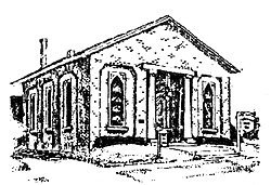
Wapakoneta Local History Museum ~ Is housed in the original First Presbyterian Church built in 1861-1862, the oldest Protestant church in Auglaize County. The structure is achitecturally as well as historically significant, and is today home to many historical items collected from Wapakoneta and Auglaize County. Click HERE to learn more about the Wapakoneta Museum. Located at 206 West Main Street, Wapakoneta, Ohio. Hours: 1st and 3rd Sundays of each month 1-4 pm.

Auglaize County Court House Gary Log House


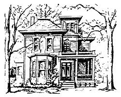
Gary Log House ~ A hand hewn log home built about 1850. Located in the 1100 block of West Auglaize Street. Hours by appointment only.

Auglaize County Court House ~ Built in 1894, it is a well preserved example of elegant 19th century architecture, containing many of its original furnishings. Located at the corner of Willipie and Mechanic Streets. Hours: Monday - Friday 8:30 am - 4:30 pm.

Neil Armstrong Air & Space Museum


Neil Armstrong Air & Space Museum ~ An outstanding regional museum of the Ohio Historical Society with exhibits about Armstrong, the first man on the moon, and space exploration. Located on Apollo Drive near Interstate 75. Hours: March through November, Monday - Saturday 9:30 am - 5:00 pm; Sundays and holidays noon - 5:00 pm.


Back to Top

Waynesfield

Historic Photo Display ~ While visiting the Village of Waynesfield, be sure to stop by the public library and see the display of historic photographs that show some vintage views of the town. Located at 108 East Wapakoneta Street. Hours: Monday - Thursday 2-6 pm, Saturday 1-5 pm, closed Friday and Sunday.


Home Page Trustees Newsletter Members Links Tour

Help Us To Preserve History
© 2003 The Auglaize County Historical Society
All Rights Reserved